-
When and where did the North Dakota Public Service Commission (PSC) hold public hearings?
-
What was the timeline for the PSC's siting (permitting) process?
-
Why was the river crossing moved from north of Bismarck to the current location?
1. Where can I find documents related to the pipeline project?
All Public Service Commission materials are available through the online docketing system. View records filed for Dakota Access Pipeline.
2. When and where did the Public Service Commission (PSC) hold public hearings?
There were three public hearings:
- May 28, 2015, at 8:30 a.m. Central Time, at the Baymont Inn (formerly the Seven Seas Hotel), 2611 Old Red Trail, Mandan, North Dakota 58554.
- June 15, 2015, at 9:00 a.m. Mountain Time, at the High Plains Cultural Center, 194 Central Ave South, Killdeer, North Dakota 58640.
- June 26, 2015, at 9:00 a.m. Central Time, at the Ernie French Center, 14120 Highway 2, Williston, North Dakota 58502.
3. How were the hearings advertised/noticed to the public and was the Standing Rock Sioux Tribe Notified?
The notices are submitted to the North Dakota Secretary of State's office to be published for an open meeting. Notice of each hearing must be given by the Commission at least 20 days prior to the hearing by publication in the official newspaper of each county in which any part of the site, corridor, or route is proposed to be located. The notices are also sent to local, state and federal officials/agencies as outlined in North Dakota rules Chapter 69-06-01.
The requirements include notification to the North Dakota Indian Affairs Commission. In this case, the North Dakota Indian Affairs Commissioner personally contacted Standing Rock Sioux Tribe Chairman Archambault’s office inviting and urging them to participate. The tribe did not testify at any of the hearings, nor express any concerns to the Commission during the 13-month permitting process.
In addition to the requirements, the North Dakota Public Service Commission also send out a news release before each public hearing. The news releases were distributed to media statewide and are also posted on our website. Media coverage for this project and the hearings was extensive. Details about North Dakota Public Service Commission public hearings are also distributed via their Twitter account, @NDPSC.
4. What was the timeline for the PSC's siting (permitting) process?
Dec. 22, 2014 – Application submitted to the North Dakota Public Service Commission
May 28, June 15, June 26, 2015 – North Dakota Public Service Commission Public hearings held in Mandan, Killdeer and Williston
Jan. 20, 2016 - Siting permit issued - After the hearings, the North Dakota Public Service Commissioners spent the next 6 ½ months working through all the issues before a siting permit was issued.
The North Dakota Public Service Commission remains involved as the construction and reclamation occurs to ensure the provisions of the Energy Transfer Partner's order (permit) are being met. The North Dakota Public Service Commission required an extra $100,000 in siting fees from the company to support a more vigorous third-party construction inspection program.
5. Who owns the land along the route of the pipeline?
Except for the water crossings, the entire route of the Dakota Access Pipeline in North Dakota traverses private land. All of the easements were obtained voluntarily from landowners without the use of eminent domain. The pipeline does not cross tribal lands. The pipeline route closely follows an existing corridor for a natural gas pipeline that was built in 1982 (see image below).
6. How are cultural resources along the route protected?
The entire 350-mile route and construction corridor were examined on foot for cultural resources by certified archeologists. More than 500 cultural resources were identified. The route was altered 140 times to avoid and protect these cultural resources before construction. The State Historic Preservation Office (SHPO) reviewed all of the archeological studies and provided a “no significant impact” determination on the entire project. The SHPO also reviewed and approved an unanticipated discovery plan that spells out the process for halting construction and protecting cultural resources if they are discovered during construction.
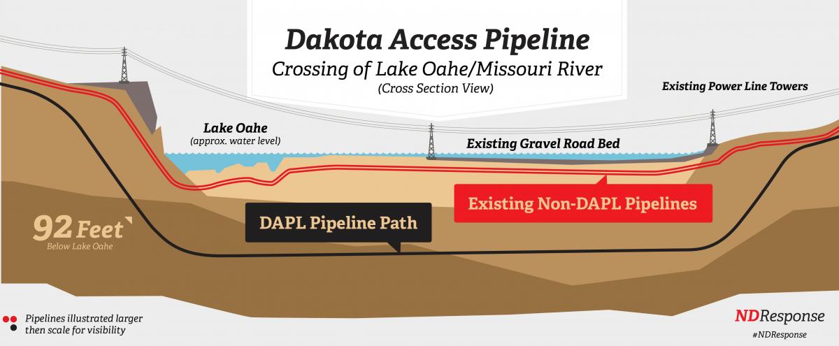
7. What safety measures are taken at the Missouri River crossing?
During the crossing of Lake Oahe on the Missouri River, the Dakota Access Pipeline will never come in contact with the water. The extra thick steel pipeline will be directionally drilled below the bottom of the lake, with 92 feet of clay and other soils separate the pipeline from the water. Other features further mitigate the risks of environmental damage, including:
- Emergency block valves are located on both sides of the river and can be remotely operated to minimize the amount of product in the pipe in case of an emergency.
- The pipe has an effusion bond epoxy coating to protect against corrosion, and will be monitored 24/7 for pressure, temperatures and volumes. Drops in pressure or volumes would indicate a leak and the pipe can be shut down immediately.
- The entire route will be visually inspected by plane or foot every two weeks and will be internally tested to federal standards with a smart device that can detect anomalies in the pipe.
8. Why was the Missouri River crossing moved from north of Bismarck to the current location?
The “proposed north crossing” that has been referenced was not part of the final route in the application filed with the PSC. The north of Bismarck location had been ruled out during earlier environmental assessments completed with the Army Corps of Engineers in determining the best possible route for the pipeline.
9. How many pounds of debris was removed from the camps?
Over 9.8 million pounds of garbage was removed from the camps.